Hiking the Wonderland Trail: Gearing Up
To plan our trip, we used this awesome trip planner initially, then read guidebooks and cross-referenced that with our permit and now, finally, have a mile-to-mile sense for what we’re headed into. Saturday, 4 of us all fly into PDX from various start-points, crash on a friend’s floor that night, and head toward Mt. Rainier early Sunday morning. We hit the trail that afternoon or the next day, and proceed to circumnavigate one of the most active volcanoes on the North American continent. According to the NPS website, “The 93-mile Wonderland Trail encircles the mountain, offering hikers commanding views of Mount Rainier blanketed by 25 icy glaciers. The trail leads through extensive subalpine meadows of wildflowers and lowland old growth forest.” All totaled, we’ll hike about 100 miles in 9 days, traveling clockwise around the mountain. Videos galore are right here, and here’s the big map:
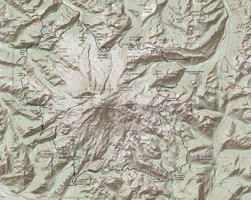 |
| The Wonderland Trail is the thick, black line around the 14,410′ Mount Rainier, which is 500,000 years old and classified as an “episodically active” volcano. |
One way to understand what 22,000 feet of elevation change over the course of 93 miles looks like, is to study a profile map. Here’s one for the Wonderland that makes my heart beat faster. Profile maps can be confusing, because the impluse is to equate the line that moves from left to right across the graph as the ridgeline…but it is not. It is the elevation line. Profile maps are helpful to hikers who like to make comparisons; having completed one day of the trip and seeing how that looks on the profile map, a hiker can gauge future days (and strenuousness) by getting a feel for how they performed and what’s to come.
For readers who like to check out the trail in real time, Mt. Rainier is web-cam savvy with more links than I’ve seen on any trail in years. Check out this link, scroll down, and do the sun dance on my behalf if all the images look grey and wet. I don’t mind the rain, but I’ll admit I’m hoping for more warm, sunny, dry days than not. So far, the 10-day forecast for our trip looks startingly–almost dreamily–dry. I’ll take it! (We’re technically only on trail 8/25-9/2 with a little wiggle room at the beginning depending on our ability to persuade the rangers about a permit change…)
After the trek, I’ll be back online just in time for a reading on Friday, September 5th at 9:00 a.m. at the 1st Baptist Church in Burnsville, NC as a part of the kick-off to the 2014 Carolina Mountains Literary Festival. I’m also teaching an afternoon memoir writing workshop that will be fun, provocative, and productive. I hope you’ll attend! Afterwards, I’ll blog about The Wonderland and post my best pics.